After realizing that I hadn’t ridden the XT at all since the Wind Dancers Pacific Rally last September, I knew it was time for an afternoon ride. Fortunately, my Wind Dancer friend Jenny and her Suzuki DR200 were available, so we made plans to meet at the local diner and hit the southern Santa Cruz Mountains.
There was a bit of drama in the days preceding our ride, as a teensy tiny innocuous-looking LED on my 12v socket had spent the past three months viciously sucking the life out of the XT’s battery. Fortunately, I tried to start the bike early enough that it could go onto the charger until the day of our ride. Sigh. As if I wasn’t feeling guilty enough for not riding the bike!
Jenny and I met at Bobbi’s Diner in Cupertino and enjoyed a leisurely breakfast while chit-chatting about dualsports and riding in general. She hadn’t been sure whether to bring her BMW F650GS (the one she’d ridden near Yosemite with me) or her DR200; I was glad she’d brought the DR as it would give me a chance to compare these two tiny dualies. The XT has 25cc more displacement than the DR but otherwise, the bikes are pretty functionally identical. They’re both single-cylinder, air-cooled, four-strokes with similar weights (~240 lbs), brakes (single-disc front; drum rear), and seat heights (31.9″).
After breakfast, we hopped onto the freeway for about eight miles; I think this was where the XT had the distinct advantage. With 25 more cc and another gear (the XT has six gears; the DR, five), I was able to comfortably cruise at 65mph in the right-hand lane. Jenny was able to keep up, but she said afterwards that the ride was amazingly vibratory and headshaky for her. Obviously the XT gets that “knobbies on the freeway” feel, too, but I got the impression that the DR had it more.
Once we got off the freeway, the fun really started. Sure, we were still on paved roads, but who can complain about 40mph sweepers through hilly farmland and alongside reservoirs? Not I! We took Almaden Expressway, McKean Road, and Uvas Road southeast. For a while, we were in front of a cruiser rider whom we both waved past early on. Sadly, he wound up being more of an unkind caricature — he’d gun it in the straights and then crawl through turns. Honestly, if you’re being tailgated through 40mph sweepers by a 225cc dualie, you might want to reconsider your cornering strategy.

After Uvas Road turns onto Watsonville Road, we stopped at my favorite little park, Chitactac-Adams Heritage County Park. My adoration for this little park truly knows no bounds — for some reason, the whole thing just makes me very, very happy. There’s gorgeous scenery and a little interpretive trail, and petroglyphs! I mean, really. We didn’t walk around the park this time (Jenny’s already paid that particular due of riding with me, when I dragged the Wind Dancers there last April), but instead just took a short break and appreciated the sunlight. A couple parked next to us in a pickup, and out bounced the cutest little miniature pincher puppy. We awwwwed and cooed over him for a few minutes before gearing back up for the next section — dirt!
Just past Chitactac-Adams, we made the righthand turn onto Redwood Retreat Road. It starts out paved, and gets progressively narrower and narrower. I missed the lefthand veer onto Mt Madonna Road — just as I always do — so we got a little U-turn practice in. 😉 See how considerate I am about helping my friends improve their slow-speed maneuvering? Once we were on Mt Madonna, the pavement quickly deteriorates and then abruptly disappears altogether. The next mile and a half or so seems ten times that long (in a good way) as it heads up the hill. I’d last been on this section of Mt Madonna in March 2005, so the road condition was similar — lots of ruts from winter streams, exposed tree roots, rocks scattered about. I imagine it’s much the same during other times of the year, though probably the stream-cut ruts aren’t as deep.
Just like last time, traffic was light — only one car of tourists who seemed very confused to see oncoming traffic as they rounded a corner. Luckily, Jenny and I were both keeping way to the righthand side, so we didn’t have to react very suddenly to their cluelessness. We stopped at the wide lefthand turn that always seems to have a waterfall right at the apex (well, at least in wintertime). Next time I need to bring my tripod, as the waterfall is gorgeous, but buried deep within the redwoods, leaving clear photos nearly impossible. It might as well have been 4pm on a cloudy day, it was so dark back there.
 |
I was really happy with the way I was riding. Sure, I was generally clueless about which gear I wanted to be in (First! No, second! No, wait, first!), but I kept my eyes up, the throttle smooth, and my head over the bars while standing on the pegs. Go me!
All too soon, we got to That Big F’ing Tree at the summit of Mt. Madonna, and we turned right onto, well, Summit Road. So Summit Road was a bit of a vendetta for me. Waaay back in September 2004, I rode up Loma Prieta Ave for the first time, on the SVS, and was deterred by the dirt road leading down Mt Madonna/Summit Road from that side. I took a photo, knowing I’d be back. Four months later, I had a dual sport. In March 2005, I tried Summit Road from the south, but was deterred by an unfriendly-looking “private road only — no trespassers!” sign. In August 2005, Peter and I made it back up Loma Prieta, to Mt. Madonna/Summit Road…but had to turn back as it was getting dark. Once again, I took a photo.
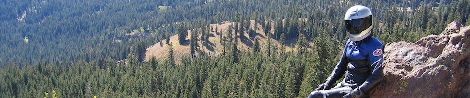
So this brings us to my ride with Jenny. This time we flagrantly ignored the “private road” sign (I’d been assured by People On Teh Intarwebz that we wouldn’t have problems as long as we were respectful) and headed northwest on Summit. And what a wonderful road it is! We took it easy, going about 15mph, enjoying the road and the scenery and the bikes. Due to the recent rain, it was a gloriously clear day, and the vistas seemed endless. We stopped a couple of times for photos, but mostly we just rode. We did have one brief interlude with a couple of dogs who wanted us off their property — I tried to go slowly enough so that I wouldn’t hit them, but quick enough to get by. They were lab-sized and snippy, and I think we were all relieved when Jenny and I got out of sight.
 |
 |
 |
This is earthquake country. We rode along and atop the San Andreas faultline, responsible for the devastating 1989 Loma Prieta earthquake, whose epicenter and namesake was the mountain less than a mile to the east.
 |
Right at the private gate to continue up to Loma Prieta’s summit, Summit Road becomes Loma Prieta Road. Shortly thereafter, the road becomes paved again for a very short while. Like I always do, I missed the righthand turn to continue on Loma Prieta Avenue (reminder to self: turn when you see the little cluster of mailboxes….). More U-turn practice! Loma Prieta after that turn quickly becomes dirt again. There are more photos of this section from Peter’s and my ride here last August. It was shorter than I remembered it — I guess stopping for pictures every 10 feet makes a section of road seem longer. 😉
All too soon, Loma Prieta kicked us back onto Summit Road, which remains paved from here on to its northern terminus past Highway 17. Jenny and I made a quick stop at the Summit Store (I tried to buy Kleenex for my lingering cold, but they didn’t have any travel packs!) and decided to continue our “Santa Cruz Mountains” theme up the next ridge. All paved roads, sadly, but we continued north along Summit Road, then Bear Creek Road, then Skyline Road, all the way up to the major intersection at Highways 9 and 35. It’d been a while since I rode that southern section of Skyline — it was cold up there, and narrow. I wanted to stop and photograph the llama farm, but there wasn’t a good place to pull over. There were at least a half-dozen big fuzzy guys hanging out by the roadside, looking fairly docile and, well, llama-ish.
At Highway 9, we descended the hill to the east, heading back down into Saratoga. We jagged back up into the hills at Pierce Road, rode the summit a little along Mt. Eden, and then headed back down to Stevens Canyon Reservoir for our final photo stop.
 |
 |
Trip stats:
Trip odometer: 89.0 miles
Max speed: 65.2 mph
Moving average: 29.2 mph
Moving time: 3 hours, 2 minutes