Motorcycling and local history seem to go hand in hand, don’t they? It seems that whenever I spend a weekend
with a particular road or area, the following week always finds me searching online for information, trivia, more pictures about
the area. Usually, a weekend trip has me covering hundreds of miles, which can make the history lesson a bit overwhelming.
This weekend, however, I took a more accessible 35-mile run through Los Altos Hills and up to San Mateo.
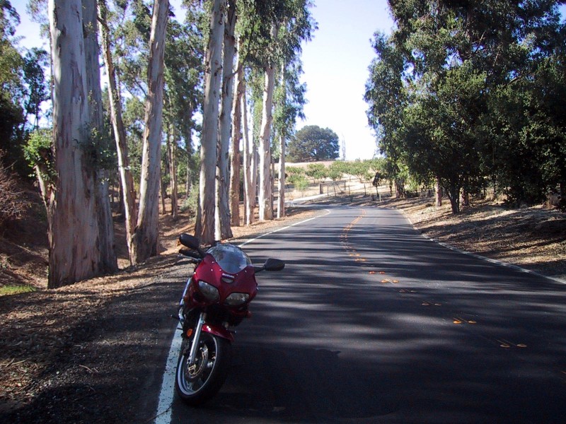
To get to Los Altos Hills from Palo Alto, I start on Page Mill Road and head south. The first stoplight after you leave Palo Alto
proper is Deer Creek Road, which is the nicest way to get over to Arastrodero Road. It goes through a
horse farm (note: those pictures were taken last
April, hence the green hills) and passes by the campuses of both Agilent Technologies and Xerox PARC. Take a right onto
Arastradero.
A couple of blocks later, I usually hang a left onto Purissima. There’s an interesting story behind the name of this street — it’s
named for Rancho La Purissima Concepcion, one of two large Spanish-Mexican land grants that make up present-day Los Altos Hills.
The land grant comprised of over 4000 acres that were eventually sold for $300 in 1844. For even more local trivia, 3000 of those
acres were then sold in 1855 to Martin Murphy, the founder of Sunnyvale.
Almost immediately, I turn right onto Elena and then again onto Natoma. Turn right onto Black Mountain, and soon you’ll be at the
intersection with Altamont Road. Altamont Road’s largest claim to fame is the
Westwind Barn, best known for its Westwind 4-H Riding for the Handicapped riding program. The Westwind Barn is located roughly
at the intersections of Altamont and Black Mountain Roads — unfortunately, I have no pictures of the area right now; I’ll have to
remedy that during my next ride up Altamont Road!
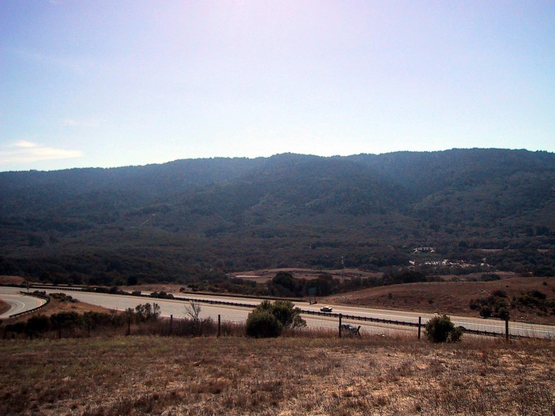
Altamont is really my reason for coming up here. There’s never any traffic; the roads are clean and well-maintained; the scenery
is excellent. It’s twisty enough that it’s interesting, but pleasant enough so that you can still let your eye wander a little
bit and scope out the hills and trees. My favorite spot is about halfway down, where an open space preserve stretches out into
the distance on the left, and a small creek runs through a mini-forest of tall pines on the right. There are almost always
deer behind the fence that separates the road from the open space preserve, so be especially careful around dusk and dawn.
Locally, Los Altos Hills has a reputation for being a watering hole for wealthy Silicon Valley executives. Even
the town’s official website admits “the market value for
unimproved building sites is currently estimated at $2M per acre”, with the minimum lot size being an acre. Obviously, living in
Los Altos Hills isn’t for all of us, but thanks to the open space preserves surrounding the area, anyone can ride through the
foothills and still enjoy the same views as the execs.
When Altamont meets up with Moody Road, I take the latter back to Highway 280. From there, it’s a quick jaunt up the freeway
to San Mateo. Normally, freeway riding isn’t anything to get excited about, but this stretch of 280 is really beautiful.
It runs along the Santa Cruz Mountains, which separate Silicon Valley from the Pacific Ocean (also known as the San Andreas
Faultline…). They’re not the world’s tallest mountains, obviously — the
tallest peak is Mt. Loma Prieta, at 3486′ — but they provide gorgeous scenery along the highway. Mt. Loma Prieta, incidentally, was the epicenter of the
1989 Loma Prieta earthquake, hence the quake’s name — it’s a common
misconception that there’s a town somewhere called “Loma Prieta”.
As you pass back through Palo Alto, you’ll
ride right over Stanford University’s linear accelerator (which, incidentally, just celebrated its 40th birthday). From Redwood City
until our stopping point in San Mateo, 280 runs through the San Francisco Fish and Game Refuge, best known for Filoli Gardens and
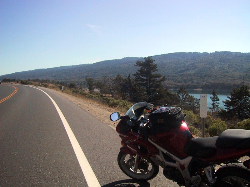
Mansion. As you near San Mateo, there are a few nice vista points that offer pretty views of the hills, 280 itself, and
nearby reservoirs. I stopped at one just north of Edgewood Road, in the Pulgas Ridge Open Space Preserve (no, I didn’t pick up
any fleas while there…). To provide a stunning bit of cohesion between this and my last trip, the Hetch Hetchy Aquaduct also
ends right about here, at the aptly named Pulgas Water Temple, which feeds into the Upper Crystal Springs Reservoir.
It puts an interesting spin on things, knowing that the water you’re seeing there in the picture came from a few hundred miles
away, in the Central Valley, and is at the heart of a huge political battle at the moment.
I exit 280 at the Highway 92 off-ramp eastbound towards Half Moon Bay. Sometimes I continue on to the coastal city, but
on this day, traffic was terrible, so I stuck with my original plan. A U-turn allows access to Ca�ada Road, one of the area’s
hidden treasures. It runs parallel to 280 from 92 south to Highway 84 in Woodside, and offers even closer views of the Upper
Crystal Springs Reservoir. The road is always light-trafficked by cars, but be careful of bicyclists. Despite the almost complete
lack of cars, the cyclists take their territory very seriously, and have yelled at me on more than one occasion for parking my
motorcycle in a bike lane to take pictures (despite them feeling free to ride three and four abreast in the main car lanes…).
Also, don’t speed through here. The speed limit is 55mph through most of it, which is fast enough, and I’ve heard rumors of
bored cops in Belmont being more than happy to write you a ticket.
When Ca�ada Road hits Highway 84 in Woodside, you have the perfect excuse to head westward up to Alice’s Restaurant. I’ll go
eastward for a block or so now, though, and hang a sharp right onto Whisky Hill Road. It continues along the same vein as
Ca�ada, through the Jaspar Ridge Biological Preserve, until it intersects with Sand Hill Road right at the very tip of
the Stanford Linear Accelerator. Another piece of Stanford trivia: Sand Hill and Whisky Hill Roads mark the western edge
of the Stanford Lands property, which is a pretty impressive chunk of land — just over 8100 acres. Sand Hill Road is perpetually under construction,
so I recommend avoiding it at all costs, unless you’re using it to take you back to Highway 280 and home.