February 13, 2005
We got up early again (well, early for Peter which, admittedly,
isn't saying much) and had breakfast at the 49er Cafe at Furnace
Creek Ranch. I walked next door to the general store and bought a
long-sleeved T-shirt; I wondered why some of the shirts said
"Death Valley, est. 1933" and some said "Death Valley,
est. 1994". Turns out that President Hoover proclaimed Death
Valley a National Monument in 1933;it became a National Park under the
Clinton Administration's Desert Protection Act in 1994.
The
first item on our agenda was to head south to see the wildflowers along
Badwater Road. I'd heard that the wildflowers were blooming in
force after record rainfall last summer (including a fatal flash flood in August).
Heading
south on Badwater Road, our first stop was at Badwater Basin, about 15
miles south of Furnace Creek Ranch. Since it was winter, the salt
pools formed an unofficial "Badwater Lake". The water in the
Badwater pools isn't posionous, just salty, and actually supports
some life. At 282 feet below sea level, Badwater is the lowest point
in the Western Hemisphere.
Peter at the edge of
"Badwater Lake" 
After leaving the basin, we
continued south on Badwater Road for about 20 more miles. The road
swoops alongside the basin the entire way, making for some great
scenery -- desert rock formations to the left, endless salt basins to
the right.
About 40 miles south of Furnace Creek, we started noticing
Desert Gold wildflowers lining the road. Naturally, I stopped so that
the bikes could pose: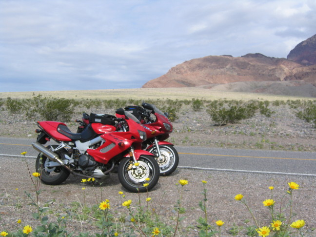
We continuted south, as we'd
heard that the most spectacular flower displays were just north of the
abandoned Ashford Mill. I didn't honestly know where
that was, but we were promised that we'd know it when we saw
it.
I rounded a curve and suddenly, there it was! Desert
gold in bloom as far as the eye could see. Green rolling hills,
flowers everywhere -- this was Death Valley? Fortunately, the flowers
grew up amongst the hard desert rocks and craggy bushes so that we
could remember that we were still in one of the hottest and least
habitable spots on earth.


We took a bazillion photos of
the wildflowers before heading back north along Badwater
Road.
Peter was in the lead during this section and he decided
to stop at Golden Canyon (a popular hiking spot a couple of miles south
of Furnace Creek). We got some funny looks from other tourists as we
climbed up the rocks in our motorcycle gear, carrying tankbags.
The padded butt
on my bike pants sure made it easier to slide down the slate rock face
on my way down, though...

We arrived back at the Ranch
around 2pm, just in time for a quick hamburger before continuing north.
After lunch, we continued north along Highway 190 out of Furnace Creek
to the North Highway turnoff. I'd never been on North Highway
before -- what an AWESOME motorcycling road! It's about
45 miles long, straight in parts and curvy in others. There are
sections of roller-coaster dips and bumps -- lots of fun at -- ahem --
65mph.
We came across
very little other traffic, so we zoomed and bumped and dipped alone,
for the most part. The road is lined with creosote bushes, some
smatterings of wildflowers, and desert rocks.
There's a
ranger station a couple of miles south of Scotty's Castle, so if
you're a scofflaw like me, you will actually have to pay the park
entrance fee ($5 for motorcyclists).
From the ranger
station, the road up to Scotty's Castle is pretty narrow and twisty --
beware of lumbering RVs bearing down at you! The Castle
itself is pretty neat; it was built in the 1920s for Death Valley
Scotty, a local legend who invented a gold mine and kept investors
paying for shares in its imaginary output. The stock market
crash of 1929 prevented the Castle from being finished, and parts of it
-- like the swimming pool in the foregroud of the photo below -- will
never be finished.
We didn't have enough time
to take a tour of the Castle and still make it to Ubehebe Crater, so we
promised to come back another time (particularly for the underground Technology Tour).
To get to Ubehebe Crater, you ride almost all the way back to
the ranger station and then head west on a tiny little road. This
road's definitely an adventure! It's tight and curvy and
washboarded with these impossibly regular buckles that run
perpendicular to the road. They're like little ridges that
you hit every 50 feet or so -- way to find out how your
suspension's doing!
The scenery
up to the crater is really neat; it's all volcanic debris: black
rocks, ashy hills, etc. Light-colored creosote bushes poke up
from the ash, giving it a cool spotted appearance.
The crater itself is really neat
-- from the USGS site: "Some of Ubehebe Crater field's most
dramatic eruptions occurred when magma met water-soaked bedrock and
alluvial fan sediments. In an instant, water flashed to steam, and a
violent release of steam-powered energy blasted away the confining rock
above. It produced a dense, ground-hugging cloud of rocky debris which
surged out from the base at up to 100 miles/hour, decimating the
landscape. A fiery fountain of lava erupted with a roar, forming
a vent to the south of what is now Ubehebe Crater. Liquid rock was
thrown into the air, then fell to the ground as solidified
cinders or partially-molten lava blocks and bombs. A ring of
black volcanic material soon builds around the central vent. The first
of the Ubehebe Crater complex is born."
Peter and I split up on the way
back to Furnace Creek Ranch -- I wanted to stop for photos and he
wanted to open up the Superhawk in the empty desert.
He waited
for me at the intersection of Hwy 190 and North Highway...I think he
said he waited for almost a half-hour, and I wasn't THAT slow, so
he must have had a fun ride back.
The day's mileage ended up being just about 200 miles
-- here's a map.
We
had dinner at the "steakhouse" at the Ranch -- we split some
chicken fettucine, which ended up being a perfect amount of food.
I had two glasses of Mojave Gold from the Indian Wells Brewing Company
-- fortunately, it tasted better than the brewery looked -- we passed
it on our way into Death Valley (it's on Hwy 14 outside of
Inyokern) and the building looked pretty delapidated.
Next time
I'll have to stop for a tour.